The Magellan spacecraft was constructed at the JPL in California. It had a new imaging radar system known as Synthietic Aperture Radar, or SAR, which could pierce through the thick cloud layers of Venus.
The satellie is almost three stories tall. Magellan launched in 1989 and arrived at Venus in 1991. It mapped over 99% of Venus at 75 M/pixel. Emmisivity was derived from micorwave energy given off by the planet. Gravity measurements were made by observing the changes in course caused by gravity anomolies on the surface of Venus. Elevation data was also taken for 99% of the planet at a resolution of 4 km/pixel. F-MIDR's were created to observe small scale structures which were of interest to researchers and scientists. F-MAPS are now being created for the entire planet in Quadrangle sizes. Quadrangles are 10 degrees on a side. Each F-MAP is devided thirty-six time into full resolution. At last check there were 55 F-MAPs created.
|
|
|
 |
 |
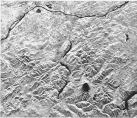
| The evolution of imaging radar is illustrated in these images of the Mount St. Helens region of Washington, which are simulations derived from the data acquired from the Seasat satellite. In the Venera image St. Helens is not discernable between an impact crater or a volcano while in the Magellan image the volcano is easily recognized. | |